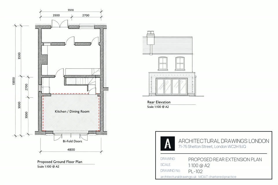
Planning Drawings Explained: What Your Application Must Include

Planning drawings are the scaled technical documents — location plan, site plan, existing and proposed floor plans, elevations, and sections — that a local council requires before it will validate and assess a planning application, as set out in each borough's local validation checklist under the Town and Country Planning Act 1990. Councils will not accept sketches, estate agent floor plans, or photographs in place of properly scaled drawings; every submission needs a 1:1250 location plan with the site edged in red, a 1:500 (or 1:200) site plan, and existing and proposed plans, elevations, and sections typically drawn at 1:50 or 1:100. Missing a required drawing, using the wrong scale, or drawing the red line boundary inconsistently with the title plan is the single most common reason a London borough returns an application as invalid before assessment has even begun. Full guidance on validation requirements is published on the Planning Portal at planningportal.co.uk and echoed in each council's own local list.
Getting this drawing set right the first time, prepared by someone who understands exactly what each borough's validation team checks for, is what keeps an application on the eight-week statutory clock rather than losing weeks to resubmission.
What must a London planning application actually contain?
Existing and proposed plans and elevations, a site plan and a location plan, each at a stated scale with a scale bar and north point. Local validation lists add to that — several boroughs require a design and access statement inside a conservation area.
| Drawing | Scale | Required by |
|---|---|---|
| Location plan | 1:1250 | national validation requirements |
| Site or block plan | 1:200 or 1:500 | national validation requirements |
| Existing plans and elevations | 1:100 or 1:50 | national validation requirements |
| Proposed plans and elevations | 1:100 or 1:50 | national validation requirements |
| Design and access statement | — | local list, usually in a conservation area |
| Householder application fee | £548 | statutory, England 2026 |
| Free resubmission after a decision | once within 12 months | statutory |
Sources: article 7 of the Town and Country Planning (Development Management Procedure) (England) Order 2015 and each borough’s published local validation list; fees from the Fees for Applications Regulations 2012 as amended, 2026 rates. Read at 1 September 2026. Validation is a separate hurdle from determination: an application that fails validation is not refused, it is simply never registered, and the eight-week clock never starts.
What Drawings Does a Planning Application Need?
Every borough publishes its own local validation checklist, but the core drawing set required is consistent across London and indeed most of England:
- Location plan — 1:1250 scale, based on an up-to-date Ordnance Survey map, with the application site edged in red and any other land in the same ownership edged blue.
- Site plan (block plan) — usually 1:500 or 1:200, showing the site boundaries, the building's footprint, access, parking, and its relationship to neighbouring plots.
- Existing floor plans — at 1:50 or 1:100, showing the property as it currently stands, room by room.
- Proposed floor plans — at the same scale, showing the development as it will be after the works.
- Existing and proposed elevations — every external face of the building, at the same scale, showing materials, window and door positions, and roof form.
- Sections — vertical cuts through the building showing floor-to-ceiling heights, roof pitches, and how the proposed works relate structurally to what exists.
- Roof plan — for loft conversions, dormers, and roof alterations, showing the existing and proposed roof form from above.
Larger or more sensitive schemes may also need a Design and Access Statement, a Heritage Statement for listed buildings or conservation areas, a Flood Risk Assessment in flood zones, or an arboricultural report where trees protected by a Tree Preservation Order are near the works.
What Is a Red Line and Blue Line Plan?
The red line on a location plan marks the boundary of the application site — the land the planning permission, if granted, will apply to. It must match the title boundary held with HM Land Registry as closely as possible; a red line that clips a neighbour's garden, or omits part of the applicant's own garden that the works will affect, is a common cause of query or invalidation.
A blue line marks any additional land in the same ownership that is not part of the application site but is relevant context — for example, a driveway or garden area the applicant owns but which is not being built on. Not every application needs a blue line; it is only required where such adjoining land exists and is owned by the applicant.
Why Do Councils Draw a Distinction Between Existing and Proposed Plans?
A case officer needs to see precisely what is changing, and existing plans are the baseline against which the proposed works are judged. Existing drawings must reflect the property as it genuinely stands — not as it was originally built, and not as a previous, unauthorised alteration made it appear. Where a previous extension or conversion was carried out without permission or a completion certificate, this can complicate the existing drawings and, in some cases, needs to be resolved (for example through a retrospective Lawful Development Certificate application) before the new scheme can be assessed cleanly.
Proposed drawings must be drawn at the same scale and from the same viewpoints as the existing drawings, so an officer, or an objecting neighbour, can compare them directly. Inconsistent scales or omitted existing features are one of the most common reasons a validation officer sends a submission back for correction.
What Scale Should Planning Drawings Be Drawn At?
| Drawing | Typical scale |
|---|---|
| Location plan | 1:1250 |
| Site / block plan | 1:500 (or 1:200 for larger or more detailed sites) |
| Existing & proposed floor plans | 1:100 (sometimes 1:50 for smaller or more detailed schemes) |
| Existing & proposed elevations | 1:100 (or 1:50) |
| Sections | 1:50 or 1:100 |
| Detail drawings (e.g. dormer construction) | 1:20 or 1:10 |
Some councils will accept drawings at a slightly different scale provided they are clearly labelled and a scale bar is included, but drifting from the norm without good reason simply invites a validation query. Every drawing should carry a printed scale, a north point on plans, and the address and application reference once one is issued. On a typical London terrace, a proposed single-storey rear extension drawn at 1:100 might add around 18m² of floor area within a 4m depth and 3m height limit close to the boundary.
Why Do Councils Invalidate Planning Applications?
Invalidation happens before a case officer ever assesses the merits of a scheme — it is a purely administrative rejection against the local checklist. The recurring causes we see across the 33 London boroughs are:
- A missing drawing the specific borough's checklist requires but a generic national list does not mention (some councils insist on a roof plan for any roof alteration, for instance).
- A red line boundary that does not match the Land Registry title plan.
- Existing and proposed drawings at inconsistent scales, making comparison impossible.
- No north point or scale bar on plan drawings.
- Ownership certificate errors on the application form — the wrong certificate ticked where there is more than one owner, or a leaseholder, involved.
- An out-of-date or incorrect fee — the current Planning Portal fee schedule sets the standard householder application fee at £548 in England, rising where an application covers more than one dwelling or use class.
Every one of these is avoidable with a drawing package checked against the specific council's own validation checklist rather than a generic template, which is standard practice for any properly prepared planning submission.
Do Planning Drawings Need to Show Materials?
Yes, in most cases. Proposed elevations should indicate the materials to be used — brick type and bond, render finish, roof tile or slate type, window frame material and colour — either annotated directly on the drawing or in an accompanying materials schedule. This matters more in conservation areas, where officers assess whether proposed materials respect the character of the area, than on an unconstrained modern property, but most validation checklists ask for it regardless of location.
Where materials are agreed as a planning condition rather than fixed at application stage, the condition typically requires samples or a materials schedule to be submitted and approved in writing before work starts on site — a separate discharge-of-conditions process that still needs its own drawings or specification document.
What Is the Difference Between Planning Drawings and Building Regulations Drawings?
Planning drawings demonstrate what a development will look like and how it sits on the site, for the purpose of a planning judgement under the Town and Country Planning Act 1990. Building regulations drawings are a separate, later-stage document set, prepared under the Building Act 1984 and the Building Regulations, showing structural design, insulation values, fire escape routes, drainage falls, and construction detail — the information a building control body needs to confirm the works are safe and compliant to build, not whether they should be permitted to exist at all.
Planning permission and building regulations approval are entirely separate consents; obtaining one does not imply or guarantee the other. Most projects need both, prepared as two related but distinct drawing packages, usually by the same architectural technologist working through the process end to end.
How Do Basement Drawings Differ From Standard Planning Drawings?
Basement extensions carry their own drawing requirements in the boroughs where they are most common, particularly the Royal Borough of Kensington and Chelsea, where the council's Basement SPD (part of its adopted Local Plan) requires structural and hydrogeological detail well beyond a standard extension's drawing set: sections showing excavation depth relative to neighbouring foundations, a construction method statement, and often a Basement Impact Assessment prepared by a chartered engineer addressing groundwater flow and neighbouring structural stability. The London Borough of Camden and the London Borough of Islington each apply their own, somewhat lighter but still specific, basement policies (Camden's Local Plan Policy A5 among them) within their Local Plans, generally focused on limiting the proportion of a garden that can be excavated and protecting neighbouring party walls.
Because these requirements sit on top of, not instead of, the standard planning drawing set, a basement scheme's drawing package is inherently more substantial than a loft conversion or rear extension, where councils typically charge a pre-application advice fee in the region of £150–£300 for a householder-scale basement enquiry.
What Happens if a Property Is in a Conservation Area?
Conservation area status does not ban development, but it does mean the case officer will scrutinise proposed elevations, materials, and roof form against the specific conservation area appraisal document the council has adopted for that area. The City of Westminster, for example, has an unusually high proportion of its borough covered by conservation areas — including the Bloomsbury-adjacent fringe and areas such as the Fitzrovia Conservation Area — so a large share of planning drawings prepared for Westminster properties need to reference the relevant appraisal explicitly, showing how brick bond, window proportions, and roofline respect the surrounding streetscape.
Drawings for a conservation area application often need more annotation than a standard scheme — call-outs referencing existing neighbouring properties, historic photographs where available, and a short design rationale explaining material choices — even where a full Design and Access Statement is not separately required. The London Borough of Camden's own Bloomsbury Conservation Area appraisal is a good example of the level of detail — brick bond, sash window proportions, roofline — a case officer will expect drawings to address.
Can You Submit Your Own Planning Drawings?
Nothing in the Town and Country Planning Act 1990 requires a qualified professional to prepare planning drawings; a homeowner can, in principle, draw their own plans and submit them directly through the Planning Portal. In practice, very few do successfully, because the drawings need to be accurately scaled, dimensionally consistent between existing and proposed, and pitched to address the specific planning policies — conservation area guidance, basement policy, daylight and outlook tests — that a case officer in that particular borough will apply.
A architectural technologist, working to CIAT Affiliate's professional standards, combines the drafting accuracy validation requires with the local policy knowledge that keeps a scheme within what an officer is likely to approve, which across this practice's projects has produced a
Frequently asked questions
What scale should a location plan be for planning permission?
A location plan is almost always required at 1:1250 scale, based on an up-to-date Ordnance Survey extract, with the application site edged in red. Some councils will accept 1:2500 for larger rural sites, but 1:1250 is the near-universal standard for householder and urban applications across London.
Do I need existing and proposed drawings for a planning application?
Yes. Every UK council requires both existing and proposed floor plans and elevations, drawn at the same scale, so the case officer can see precisely what is changing. Submitting only proposed drawings, without an accurate existing set, is a common cause of invalidation.
What happens if my planning drawings are the wrong scale?
The validation officer will typically write to request corrected drawings before the application clock starts, or return the application as invalid if the error is significant. Either way, it delays the eight-week statutory determination period, since that period only begins once validation is complete.
Can estate agent floor plans be used for a planning application?
No. Estate agent plans are not drawn to a verified architectural scale and rarely show elevations, sections, or accurate boundary lines, so councils will not accept them in place of proper planning drawings. A validation officer will reject a submission that relies on them.
Do planning drawings need to show the roof?
Yes, particularly for loft conversions, dormer windows, or any roof alteration, where a roof plan and roof-level elevations showing the existing and proposed roof form are usually required by the local validation checklist, in addition to standard floor plans and elevations.
Is a Design and Access Statement always required?
No. Most councils only require a Design and Access Statement for larger developments, applications in conservation areas, or schemes affecting listed buildings. Many straightforward householder extensions and loft conversions are exempt, though this varies by borough, so it is worth checking the specific local validation checklist.