
Measured Building Surveys · SE25 South Norwood
Croydon applies householder control across SE25, with conservation pockets around Woodside Green; one of London's most affordable period markets.

The borough-level guide to measured building surveys in Croydon sets out how the same work is handled across the rest of the authority.
A measured building survey captures your South Norwood property exactly — every wall, opening, level and boundary — as the accurate base for design and planning drawings. On SE25's older terraced and villa stock around South Norwood, Selhurst, Woodside, Norwood Junction, walls are rarely square, so a laser-measured survey prevents costly errors before Croydon Council ever sees the application.
Leica Disto laser + BLK360 point-cloud scanning, AutoCAD and Revit deliverables, MCIAT chartered.
Across South Norwood, Selhurst, Woodside, Norwood Junction in SE25, the dominant property is victorian and edwardian terraces and bay-fronted semis around south norwood and selhurst, with post-war estates near the centre. That stock shapes what measured building survey looks like here: the right approach for a period terrace differs from a mansion-block flat or a new-build, and Croydon Council judges each on design quality and neighbour impact. We survey the specific South Norwood property, confirm the planning route — Permitted Development, a Lawful Development Certificate, or full planning — and draw a council-ready set tailored to the SE25 streetscape.
Housing stock in SE25: Victorian and Edwardian terraces and bay-fronted semis around South Norwood and Selhurst, with post-war estates near the centre.
Within the district: South Norwood, Selhurst, Woodside, Norwood Junction.
Streets we know in SE25: the South Norwood Hill streets, Portland Road, Oliver Grove and the Woodside terraces. Each road has its own building line, boundary treatment and precedent that Croydon Council weighs when assessing a measured building survey scheme.
Conservation areas: South Norwood (Lower Norwood), Woodside Green. Inside these, most external work needs full planning and a Heritage Statement.
Getting around SE25: Norwood Junction on the Overground and rail to London Bridge and Victoria, plus the tram at Woodside.
Regeneration: South Norwood falls within or beside the South Norwood / Croydon growth area, which shapes local planning policy and design expectations.
Property values: the Land Registry counted 409 SE25 sales in 2025, a quarter of them above £492,500. Contains HM Land Registry data (c) Crown copyright and database right 2026.
Borough character: Large, mixed-density outer borough; permissive in outer areas; heritage controls in conservation pockets; major regeneration in central Croydon.
A chartered technologist attends your South Norwood property with a Leica Disto laser and BLK360 scanner. Typical 2–3 bed terrace surveyed in 90 minutes.
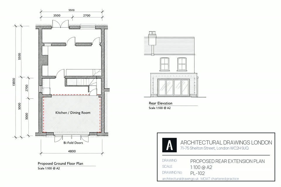
Drafted in AutoCAD or Revit at 1:50 or 1:100 to ±3mm accuracy. Every room, opening, fitting and service annotated.
All four elevations plus cross-sections — essential for South Norwood planning applications, party wall awards and structural design.
BLK360 scan delivers a full 3D point cloud — ideal for South Norwood period properties, listed buildings or complex geometry.
DWG, RVT, PDF and IFC exports — compatible with your architect, structural engineer or contractor.
RICS-compliant accuracy report — ±3mm point-to-point, ±5mm absolute. Sign-off for council, party wall surveyor or insurer.
Single planning or building-regs submission.
Planning + building regs + structural.
Listed, conservation or complex sites.

Yes. The Victorian and Edwardian terraces and bay-fronted semis around Portland Road and South Norwood Hill suit side-return, rear and loft extensions, much of it within Permitted Development outside the conservation areas, confirmed with a Lawful Development Certificate. We confirm the route and draw to Croydon's checklist.
Usually yes — a rear dormer or hip-to-gable on the semis, within the volume allowance and confirmed by a Lawful Development Certificate, provided you're not in the Woodside Green conservation area. We check the constraints for your road and draw it for Building Control.
Family-house extensions and lofts on the Victorian and Edwardian terraces and semis around Selhurst and Woodside — side-returns, rear additions and dormers as families grow. With houses around £450,000-£700,000, SE25 offers strong value, and a council-ready scheme protects both approval and resale.
Croydon's wider regeneration and the tram and Overground links keep SE25 well-connected and improving, supporting values. For a house project the binding controls remain Permitted Development limits and the local conservation area, which we check for your address before quoting.
Croydon Council charges its own statutory application fee (currently £548 for a householder planning application, £610 for a full application). We quote the drawings as one fixed price and the free site survey covers every SE25 address.
For a SE25 project across South Norwood, Selhurst, Woodside, Norwood Junction, expect roughly 3–4 weeks from instruction to submission: week 1 the measured survey, weeks 2–3 the drawings and your revisions, then validation and the statutory determination by Croydon Council (8 weeks for a householder application). We carry the South Norwood application through every officer query to the decision.
South Norwood (SE25) sits primarily in Croydon, so applications are decided by Croydon Council. Conservation areas within SE25 include South Norwood (Lower Norwood), Woodside Green, where full planning and a Heritage Statement are required. We confirm the planning route for your exact address before quoting.
Almost always. Any structural work behind measured building survey in South Norwood — new openings, steel beams, loft floors, foundations — needs Building Regulations approval covering structure (Part A), fire escape (Part B) and insulation (Part L), submitted to Croydon Council Building Control or an approved inspector. On SE25's typically terraced and semi-detached stock, a Party Wall notice to adjoining neighbours is normally required before the steelwork. We coordinate both as part of the Complete package.
In value terms, yes. The bigger risk is an unapproved or non-compliant scheme — which is why council-ready drawings and a clean Building Control sign-off matter on SE25 homes.
Extensions on a boundary plot can involve two authorities. Everything we draw and submit is listed for SE19, SE20 and SW16.
Pick a slot that suits you. No obligation and no sales pressure, just straight answers on your planning route.
Every SE25 postcode district we draw in, the stock that dominates it and the authority that validates a measured building survey there. SE25 fees below are the statutory England rates for 2026, not measured building survey estimates.
| Postcode | Area | Dominant stock | What it means for a measured building survey |
|---|---|---|---|
| SE25 | South Norwood / Selhurst | Victorian terraces | Nothing is applied for and nothing is refused — a survey simply records the building. Houses in South Norwood and Selhurst, across SE25, have usually gained a rear extension or two over the years, so the as-built plan rarely matches whatever drawing came with the sale. |
| SE25 | South Norwood | Victorian terraces | South Norwood sits inside SE25. A survey is a record, not an application, so nothing is granted or refused at this stage; its accuracy is what decides whether the drawings built on it survive scrutiny. |
| SE25 | Selhurst | Edwardian terraces | No consent is required to survey a SE25 property in Selhurst. The survey comes first so that whatever Croydon Council is later asked to decide rests on measured fact rather than an assumption about the existing building. |
| SE19 | Upper Norwood / Crystal Palace | Victorian villas, Edwardian terraces | Adjoining district to SE25. Surveying needs no consent here either — Croydon has no say in it, and the survey is the same record whichever side of the line the property sits. |
| CR0 | Croydon / Addiscombe / Shirley | Edwardian terraces, post-war flats | Adjoining district to SE25. Surveying needs no consent here either — Croydon has no say in it, and the survey is the same record whichever side of the line the property sits. |
| CR2 | South Croydon | mixed stock | Adjoining district to SE25. Surveying needs no consent here either — Croydon has no say in it, and the survey is the same record whichever side of the line the property sits. |
Roof pitch, wall build-up and plot depth change every few SE25 streets, and each one changes what a measured building survey can achieve at that address.
How designation changes a SE25 (South Norwood / Selhurst) measured building survey: Croydon Council maintains 24 conservation areas, including Shirley Park, South Norwood, Crystal Palace. Inside any of them a SE25 (South Norwood / Selhurst) measured building survey cannot rely on permitted development, and the route becomes a £548 householder application determined in 8 weeks rather than a £249 prior approval in 6 weeks. Old Coulsdon sets the tone for SE25 (South Norwood / Selhurst) casework.
No blanket Article 4 over SE25 (South Norwood / Selhurst): Croydon Council has not withdrawn permitted development across SE25 (South Norwood / Selhurst), so a measured building survey outside a SE25 (South Norwood / Selhurst) conservation area usually keeps it. The £274 Lawful Development Certificate is still the document a SE25 owner wants on file.
What SE25 (South Norwood / Selhurst) is built from: Victorian villas in Upper Norwood and Crystal Palace; Edwardian terraces in Thornton Heath and Selhurst; 1930s semi-detached in Purley and Coulsdon; post-war in Croydon central. Large, mixed-density outer borough; permissive in outer areas; heritage controls in conservation pockets; major regeneration in central Croydon. That mix decides the measured building survey route in SE25 (South Norwood / Selhurst) more than the postcode does, and it is what a Croydon Council case officer reads first. A householder application costs £548 paid to Croydon Council direct, with 8 weeks to a decision once validated.
Sources for this SE25 measured building survey page: borough policies maps and conservation-area registers (2025–26), Royal Mail postcode district boundaries, the Town and Country Planning (Fees for Applications) (England) Regulations, the Town and Country Planning (General Permitted Development) (England) Order 2015 as amended, and the Party Wall etc. Act 1996.
Free fixed quote in 60 seconds. MCIAT chartered.
Get my free quote →Or contact us about your project firstYou can browse every service and area to find the right fit, or create a free account to track your project. When you are ready, get a quote in minutes — most homeowners have a fee in minutes — or contact us for a chat and a chartered technologist will be in touch.

