
Planning Drawings · N19 Archway
N19 spans Islington and Camden; the Whitehall Park conservation area controls the hillside terraces.

This page covers one part of the borough. For the full picture — fees, timelines and the council's current position — read planning drawings in Islington.
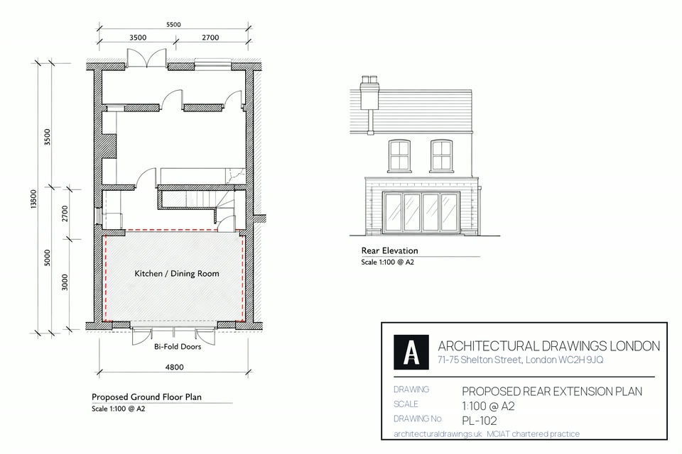
Planning drawings for Archway start by establishing whether your scheme is Permitted Development, needs a Lawful Development Certificate, or full planning from Islington Council. On N19's victorian terraces, many converted to flats, with, the recurring questions are roof additions, rear and side-return extensions, and alterations within Whitehall Park, Dartmouth Park fringe. We draw existing and proposed plans, elevations and a site location plan to the council's validation checklist for Archway, Tufnell Park, Upper Holloway, Whitehall Park.
Across Archway, Tufnell Park, Upper Holloway, Whitehall Park in N19, the dominant property is victorian terraces, many converted to flats, with steep-street housing and pockets of post-war estate on the archway and tufnell park slopes. That stock shapes what planning permission drawings looks like here: the right approach for a period terrace differs from a mansion-block flat or a new-build, and Islington Council judges each on design quality and neighbour impact. We survey the specific Archway property, confirm the planning route — Permitted Development, a Lawful Development Certificate, or full planning — and draw a council-ready set tailored to the N19 streetscape.
Housing stock in N19: Victorian terraces, many converted to flats, with steep-street housing and pockets of post-war estate on the Archway and Tufnell Park slopes.
Within the district: Archway, Tufnell Park, Upper Holloway, Whitehall Park.
Streets we know in N19: the Whitehall Park and Dartmouth Park Hill terraces, St John's Way and Junction Road. Each road has its own building line, boundary treatment and precedent that Islington Council weighs when assessing a planning permission drawings scheme.
Conservation areas: Whitehall Park, Dartmouth Park fringe. Inside these, most external work needs full planning and a Heritage Statement.
Getting around N19: Archway and Tufnell Park on the Northern line, plus Upper Holloway Overground.
Regeneration: Archway falls within or beside the Archway Town Centre regeneration, which shapes local planning policy and design expectations.
Property values: around £450,000 for a flat and £850,000-£1.1m for a house — a useful gauge of the build value an extension or loft adds in N19.
Borough character: Densely terraced, gentrified; strong conservation area coverage; active planning department.
A chartered technologist visits and laser-measures every room. Typically 60–90 minutes on site.
Drafted in Revit or AutoCAD at 1:100 or 1:50. Fully annotated and council-ready.
Unlimited revisions until you approve. Shadow studies for committee-sensitive applications.
Site location plan, block plan, Design & Access Statement where required.
We lodge the application with Islington Council and pay statutory fees directly.
Every officer query, consultation response and amendment handled through to determination.
Single planning or building-regs submission.
Planning + building regs + structural.
Listed, conservation or complex sites.

Usually yes on the Victorian terraces — a rear dormer with an L-shape over the back addition is the standard scheme, often Permitted Development outside the Whitehall Park conservation area and confirmed with a Lawful Development Certificate. Inside Whitehall Park, roof changes need full planning. We confirm which applies to your road.
N19 straddles the boundary — Archway and Tufnell Park largely sit in Islington, with the western edge toward Dartmouth Park in Camden. The two councils apply different Article 4 and conservation controls, so we confirm your exact authority before quoting and submit accordingly.
Yes. The Victorian terraces off Junction Road and St John's Way gain a much larger kitchen-diner from a side-return infill, usually within Permitted Development depth limits outside the conservation area. With houses around £850,000-£1.1m, the added space justifies a properly drawn scheme.
Archway's town-centre regeneration has improved the gyratory and public realm, supporting values across N19, but it mainly affects the centre rather than the residential terraces. For a house project, the relevant controls are Permitted Development limits and the Whitehall Park conservation area — which we check for your address.
With Archway property at around £450,000 for a flat and £850,000-£1.1m for a house, the professional drawing fee is a small fraction of the value the work adds to N19's victorian terraces, many converted to flats, with. Islington Council charges its own statutory application fee on top (currently £548 for a householder planning application, £610 for a full application). We quote the drawings as one fixed price and the free site survey covers every N19 address.
For a N19 project across Archway, Tufnell Park, Upper Holloway, Whitehall Park, expect roughly 3–4 weeks from instruction to submission: week 1 the measured survey, weeks 2–3 the drawings and your revisions, then validation and the statutory determination by Islington Council (8 weeks for a householder application). We carry the Archway application through every officer query to the decision.
Archway (N19) sits primarily in Islington, so applications are decided by Islington Council. Conservation areas within N19 include Whitehall Park, Dartmouth Park fringe, where full planning and a Heritage Statement are required. We confirm the planning route for your exact address before quoting.
Almost always. Any structural work behind planning permission drawings in Archway — new openings, steel beams, loft floors, foundations — needs Building Regulations approval covering structure (Part A), fire escape (Part B) and insulation (Part L), submitted to Islington Council Building Control or an approved inspector. On N19's typically terraced and semi-detached stock, a Party Wall notice to adjoining neighbours is normally required before the steelwork. We coordinate both as part of the Complete package.
In value terms, yes. With Archway (N19) property at around £450,000 for a flat and £850,000-£1.1m for a house, a well-designed extension or loft typically returns more than it costs in added floor area and sale value. The bigger risk is an unapproved or non-compliant scheme — which is why council-ready drawings and a clean Building Control sign-off matter on N19 homes.
Working across a borough boundary, or unsure which council will decide your application? Every service we offer is listed for N1, N4, N5, N7 and N16.
Pick a slot that suits you. No obligation and no sales pressure, just straight answers on your planning route.
Every N19 postcode district we draw in, the stock that dominates it and the authority that validates a planning drawing set there. N19 fees below are the statutory England rates for 2026, not planning drawing set estimates.
| Postcode | Area | Dominant stock | What it means for a planning drawing set |
|---|---|---|---|
| N19 | Archway / Tufnell Park | Victorian terraces, post-war flats | N19 straddles a boundary: Archway / Tufnell Park addresses fall to Islington Council or Camden Council, so confirm which authority validates the planning drawing set before submitting N19 drawings. |
| N19 | Archway | Victorian terraces, post-war flats | Archway sits inside N19; planning drawing set proposals here are determined by Islington Council. |
| N19 | Tufnell Park | Victorian villas and terraces | Tufnell Park sits inside N19; planning drawing set proposals here are determined by Islington Council. |
| N1 | Islington / Hoxton | Georgian and early Victorian terraces | Adjoining district to N19, also inside Islington for planning drawing set purposes. |
| N5 | Highbury | Victorian terraces, mansion blocks | Adjoining district to N19, also inside Islington for planning drawing set purposes. |
| N7 | Holloway / Tufnell Park | Victorian villas and terraces | Adjoining district to N19, also inside Islington for planning drawing set purposes. |
| N1C | King's Cross | Modern apartments, converted warehouses | Adjoining district to N19, also inside Camden for planning drawing set purposes. |
| N6 | Highgate | Georgian villas, Victorian and Edwardian semis | Adjoining district to N19, also inside Camden for planning drawing set purposes. |
| NW1 | Camden Town / Regent's Park | Victorian terraces, mansion blocks | Adjoining district to N19, also inside Camden for planning drawing set purposes. |
| NW3 | Hampstead / Belsize Park | Georgian and Victorian villas, listed buildings | Adjoining district to N19, also inside Camden for planning drawing set purposes. |
Roof pitch, wall build-up and plot depth change every few N19 streets, and each one changes what a planning drawing set can achieve at that address.
How designation changes a N19 (Archway / Tufnell Park) planning drawing set: Islington Council maintains 40 conservation areas, including Canonbury, Highbury, Clerkenwell. Inside any of them a N19 (Archway / Tufnell Park) planning drawing set cannot rely on permitted development, and the route becomes a £548 householder application determined in 8 weeks rather than a £249 prior approval in 6 weeks. Canonbury sets the tone for N19 (Archway / Tufnell Park) casework.
What Article 4 removes near N19 (Archway / Tufnell Park): Article 4 Direction covering the whole borough removes permitted development rights for HMO conversions (C3 to C4). Separate Article 4 for office-to-residential in key areas. Before pricing a planning drawing set we check whether the N19 address is inside the mapped area, because Islington Council draws the N19 (Archway / Tufnell Park) boundary street by street rather than across the whole of N19 (Archway / Tufnell Park).
N19 (Archway / Tufnell Park) housing stock: Georgian and early Victorian terraces, Victorian bye-law housing, 1930s mansion blocks, converted industrial buildings in Clerkenwell and Farringdon. Densely terraced, gentrified; strong conservation area coverage; active planning department. Read that before choosing a planning drawing set route in N19 (Archway / Tufnell Park) — construction, not postcode, sets what is achievable. Islington Council charges £548 for a householder application and has 8 weeks to determine it.
How designation changes a N19 (Archway / Tufnell Park) planning drawing set: Camden Council maintains 40 conservation areas, including Primrose Hill, Bloomsbury, Camden Town. Inside any of them a N19 (Archway / Tufnell Park) planning drawing set cannot rely on permitted development, and the route becomes a £548 householder application determined in 8 weeks rather than a £249 prior approval in 6 weeks. Primrose Hill sets the tone for N19 (Archway / Tufnell Park) casework.
What Article 4 removes near N19 (Archway / Tufnell Park): Article 4 removes permitted development for HMO conversions (C3 to C4) across the borough, plus restrictions on basement extensions in 12 conservation areas. Before pricing a planning drawing set we check whether the N19 address is inside the mapped area, because Camden Council draws the N19 (Archway / Tufnell Park) boundary street by street rather than across the whole of N19 (Archway / Tufnell Park).
Digging below a N19 (Archway / Tufnell Park) property: Camden's basement policy (Policy A5) restricts single-storey basements to 50% of garden area; double-storey basements generally refused outside commercial zones. Where a planning drawing set in N19 (Archway / Tufnell Park) involves excavation that is read beside the Party Wall etc. Act 1996, which needs two months notice for a N19 (Archway / Tufnell Park) dig within 3 m of a neighbour, and Camden Council expects the N19 ground conditions addressed in the application.
N19 (Archway / Tufnell Park) housing stock: Victorian and Edwardian terraces, Georgian townhouses in Bloomsbury and Hampstead, post-war mansion blocks, modern developments in King's Cross. Creative, affluent in Hampstead and Primrose Hill; dense mixed-use around Camden Town and Kings Cross; academic character in Bloomsbury. Read that before choosing a planning drawing set route in N19 (Archway / Tufnell Park) — construction, not postcode, sets what is achievable. Camden Council charges £548 for a householder application and has 8 weeks to determine it.
Sources for this N19 planning drawing set page: borough policies maps and conservation-area registers (2025–26), Royal Mail postcode district boundaries, the Town and Country Planning (Fees for Applications) (England) Regulations, the Town and Country Planning (General Permitted Development) (England) Order 2015 as amended, and the Party Wall etc. Act 1996.
Free fixed quote in 60 seconds. MCIAT chartered.
Get my free quote →Or contact us about your project firstYou can browse every service and area to find the right fit, or set up your account to track your project. When you are ready, get a quote for your project — most homeowners have a fee in minutes — or contact us and a chartered technologist will be in touch.

