
Planning Drawings · Havering
Planning Permission Drawings in Havering
No hourly billing
3–4 weeks to submission
Covering all Havering postcodes
Havering settled 97.9% of its householder decisions inside the statutory eight weeks and only 0.6% ran past thirteen, one of the tightest records in London. It approved 81.8% of 3,218 decisions. Its Datahub set records 2,293 loft applications, but only 18% of those were approved.
| Measure | Havering | London |
|---|---|---|
| Decided inside eight weeks | 97.9% | — |
| Decided beyond thirteen weeks | 0.6% | — |
| Householder approval rate | 81.8% | 83.0% |
| Householder decisions made | 3,218 | 77,680 |
| Lawful development certificates issued | 1,637 | — |
| Householder appeals allowed after refusal | 42.1% of 489 | 40.8% of 13,067 |
| Householder appeals involving a listed building | 13.1% | — |
Sources: decision figures from MHCLG District Planning Application Statistics (PS1 and PS2), twelve quarters to March 2026; appeal figures from Planning Inspectorate casework decided 2016–2026. Open Government Licence v3.0, retrieved 1 September 2026. Havering’s 13.1% listed-building share of householder appeals is the highest in London after Bromley and Richmond, which is not obvious from the borough’s outer-suburban reputation.
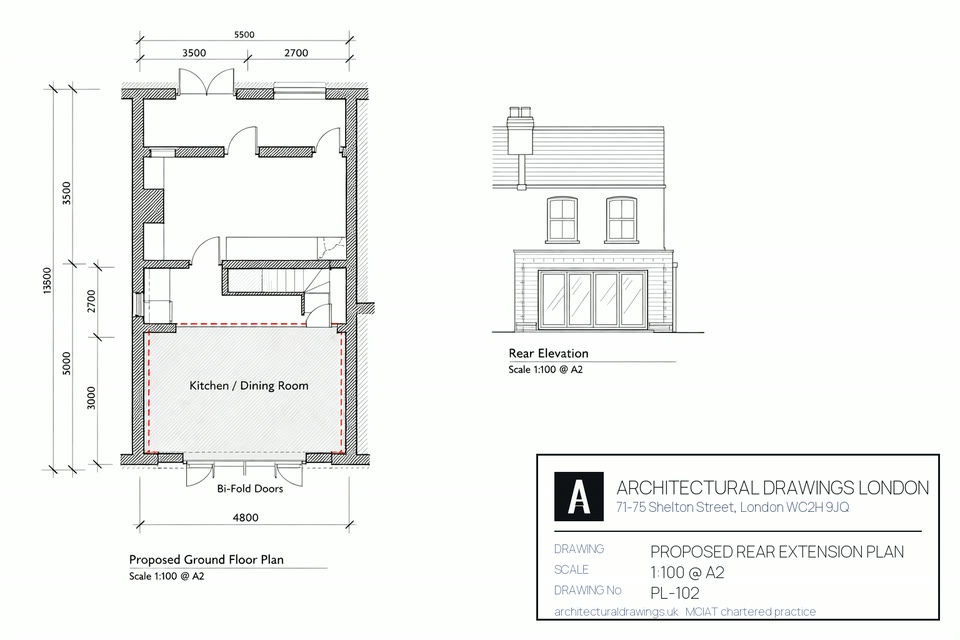
In Havering — 1930s semi-detached dominates Hornchurch and Upminster; post-war in Harold Hill and Romford; Victorian in older Romford centre for the most part — a planning permission drawings package is the full measured-survey-to-submission drawing set London Borough of Havering needs in order to determine an application: existing and proposed plans, elevations and sections at 1:100 and 1:50, a location and site plan, and the supporting statements the case officer asks for.
Prepared and reviewed by the architectural technologist team at Architectural Drawings London — CIAT Affiliate, professional indemnity insured.Last reviewed 2026-08-03.

Housing stock in Havering: 1930s semi-detached dominates Hornchurch and Upminster; post-war in Harold Hill and Romford; Victorian in older Romford centre.
Character: Outer east London; Metropolitan Green Belt covers north of the borough; permissive residential planning; strong PD use.
One of our architectural technologists comes out with a disto and records every room, accurate to plus or minus 3mm point to point. An ordinary Havering semi takes an hour to an hour and a half.
The set is drafted in Revit or AutoCAD, scaled at 1:100 for the general arrangement and 1:50 where a junction needs it, and annotated against what Havering's validation checklist asks for.
Unlimited revisions until you approve. Shadow studies for committee-sensitive applications.
Site location plan, block plan, Design & Access Statement where required.
We file through the Planning Portal to Havering Council and settle the statutory fee at submission, so nothing sits waiting on a payment from you.
Every officer query, consultation response and amendment handled through to determination.

Single planning or regs submission.
Planning + building regs + structural.
Listed, conservation, complex sites.
Move the controls for an indicative figure. It anchors your budget — it is not a quote. Every project is priced after a site survey.
Build costs are separate and quoted by your contractor. See our published fees.
The table runs through Havering by postcode district: which RM codes we draw in, what kind of housing fills them, and which authority validates a set at that address. Money quoted is the England statutory scale for 2026 — council charges, not ours.
| Postcode | Area | Dominant stock | What it means for a planning drawing set |
|---|---|---|---|
| RM1 | Romford Central | Victorian terraces, 1930s semi-detached, post-war flats | RM1 is Romford town centre and nothing else. Havering Council determines the drawing set, and the Romford Market designation bears on anything visible from the street. |
| RM2 | Gidea Park | Victorian terraces, 1930s semi-detached, post-war flats | A planning drawing set at an RM2 address in Gidea Park is determined by Havering Council under its own Local Plan policies for Gidea Park. |
| RM3 | Harold Hill | Post-war estate | RM3 is Harold Hill on its own — a post-war district where street-by-street uniformity is the reference a case officer tests a proposal against. |
| RM4 | Havering-atte-Bower | 31.9% of Havering homes are 1930s, mostly semi-detached; Harold Hill and swathes of Romford are post-war estate building; pre-1900 stock is down at 1.7%, clustered near the old market | Havering-atte-Bower sits in RM4, but RM4 is not Havering: 118 of its 160 postcodes are in Epping Forest and 14 in Brentwood (Ordnance Survey Code-Point Open, retrieved 4 September 2026). The drawing set is the same either way; the validation list it has to satisfy is not, so we confirm the authority from the address before starting. |
| RM5 | Collier Row | 1930s semi-detached | RM5 covers Collier Row alone. Havering Council decides it, and the 1930s-to-1950s suburban grain there sets the expectation for scale and roof form. |
| RM7 | Romford / Rush Green | Victorian terraces, 1930s semi-detached, post-war flats | Romford and Rush Green share RM7, and both sit wholly inside Havering, so the Local Plan that applies is the borough's own with no cross-boundary complication. |
| RM11 | Hornchurch / Emerson Park | 1930s semi-detached | RM11 is Hornchurch and Emerson Park, where plot widths are generous and the Hornchurch conservation area governs work to the frontage. |
| RM12 | Hornchurch / Elm Park | 1930s semi-detached | RM12 covers Hornchurch / Elm Park only; Havering Council handles the planning drawing set. |
Havering's stock is unusually consistent: 31.9% of its 108,670 homes went up in the 1930s and another 28% between 1945 and 1964, on VOA council tax stock data at 31 March 2025. Even so, ridge heights, cavity build-ups and back-garden depths vary from one road to the next, and each variation narrows or widens what a drawing set can propose.
Conservation areas covering Havering: fifteen are designated, and three of them — Hornchurch, Rainham Village, Romford Market — account for most of the heritage questions we field in the borough. A conservation area counts as article 2(3) land. That designation strips out Class B roof extensions, side extensions and any cladding from permitted development — a single-storey rear extension can still go the prior-approval way. The charges differ accordingly. The householder application fee in England is £548. The fee for a larger householder prior approval is £249. In Hornchurch, the frontage as seen from the pavement is the first thing an officer will assess.
Havering permitted development status: there is no borough-wide direction from Havering Council, so a planning drawing set at a RM1 address is normally still permitted development. We certify that with a £274 Lawful Development Certificate rather than leaving a Havering sale to argue it later.
Havering housing stock: 1930s semi-detached dominates Hornchurch and Upminster; post-war in Harold Hill and Romford; Victorian in older Romford centre. Outer east London; Metropolitan Green Belt covers north of the borough; permissive residential planning; strong PD use. Read that before choosing a planning drawing set route in Havering — construction, not postcode, sets what is achievable. Havering Council charges £548 for a householder application and has 8 weeks to determine it.
Sources for this Havering planning drawing set page: borough policies maps and conservation-area registers (2025–26), Royal Mail postcode district boundaries, the Town and Country Planning (Fees for Applications) (England) Regulations, the Town and Country Planning (General Permitted Development) (England) Order 2015 as amended, and the Party Wall etc. Act 1996.
Appeals against Havering on new-dwelling schemes rarely succeed. Of 500 decided between 2016 and 2026, just 91 were allowed and 409 dismissed — 18.2%, below the 22.4% London figure and among the lower rates in the capital. Better than four in five challenges fail. For anyone proposing a conversion, an infill or a small new house here, that changes where the effort belongs: the appeal is a weak backstop, so the application itself has to be right, and the local plan policies it will be judged against are worth reading before the drawings are finished rather than after a refusal.
Half of these Havering appeals ran past 118 days from start to decision, and none of it overlaps the months the council had already used up — the plainest argument there is for getting the first submission right. In 9.6% of them a listed building's setting was in play. Only 2.4% got as far as a hearing or an inquiry. The other 97.6% were written representations: an inspector decided on paper, from the drawings and the written case, with nobody present to explain either.
Drawn from 500 new-dwelling appeals decided in Havering. Source: Planning Inspectorate casework. Contains public sector information licensed under the Open Government Licence v3.0.
Short answers to what Havering owners actually ask us, week in week out, about planning permission drawings.
Start a free quote →Our fee is agreed before a line is drawn, and what sits inside it follows from which consent you need. Householder applications are the leanest; major schemes, change of use and flat conversions need a fuller drawing pack and a longer list of supporting documents, which is what lifts the price. Havering Council's own planning fee is separate and set nationally. The householder application fee in England is £548. The fee for a larger householder prior approval is £249. The fee for a lawful development certificate is £274.
Havering works to the statutory clock — 8 weeks on a householder application, 13 on a major — and mostly holds it. Of the 2,012 householder decisions taken outside a planning performance agreement across 2023-24 to 2025-26, 1,969 landed inside eight weeks. Source: MHCLG live planning statistics. On our side, three to four weeks separates the instruction from the submission.
Havering does not currently have a borough-wide Article 4 Direction for residential extensions or HMO conversions. Most householder permitted development rights apply normally in Havering — though conservation areas and listed buildings still restrict PD. We confirm at the site survey.
Fifteen conservation areas are designated in Havering, among them Romford Market, Upminster and Hornchurch. Inside one, the council weighs the effect on the area's character before it weighs anything else, and a Heritage Statement is normally expected alongside the drawings.
Havering grants 81.8% of the householder applications it decides — 2,633 of 3,218 — against 83.0% across the 33 boroughs pooled, on MHCLG's live planning statistics for the twelve quarters ending March 2026. That is close enough to the city figure that the borough is neither a soft touch nor an obstacle; what separates the 585 refusals from the rest is the drawing set. A architectural technologist secures the same permission a larger consultancy would, usually for less, and our CIAT-affiliated team runs the drawings, the submission and the correspondence with the case officer as one piece of work.
We cover all Havering postcodes — RM1, RM2, RM3, RM4, RM5, RM7, RM11, RM12, RM13, RM14 — as well as the immediately adjacent boroughs. Survey appointments are available within 3 working days across Havering.
Havering's 1930s semi-detached dominates Hornchurch and Upminster housing stock and 15 conservation areas mean that design quality matters. Havering Council officers are experienced reviewers; well-drawn, consistent applications are processed faster than revisions-heavy ones.
Yes. A refusal by Havering Council can be taken to the Planning Inspectorate as of right, within 12 weeks on a householder case. Written representations, the route almost every householder uses, run roughly 16 to 20 weeks; a hearing takes 24 to 32. The borough's record is worth knowing before you commit: 1,386 appeals have been decided here, 417 of them allowed and 969 dismissed. Source: Planning Inspectorate appeal decisions. Where a refusal rests on design or on a policy reading, we put together the appeal statement and redraw what needs redrawing.

If your property sits on a boundary, here are the neighbouring options.
One CIAT-affiliated team handles the whole job in Havering: the measured survey, the drawn set, the submission to the council, and whatever the case officer asks for after it lands.
A construction-ready drawing package compliant with every Approved Document — Part A structure, Part B fire, Part L thermal, Part M accessib...
Every loft type across every Havering roof line — dormer, mansard, hip-to-gable, L-shape, Velux. LDC or full planning route, building regula...
The whole spectrum — rear extensions, side returns, wraparounds, double-storey, basement digs. Planning-led design with detailed technical p...
Havering's most space-efficient loft solution when PD-route dormers are blocked. Our team designs mansards that get approved in Ha...
Turn your unused Havering garage into a bedroom, home office or open-plan kitchen-diner. Planning route assessment, full building regulation...
Full architectural technology service for basement digs and cellar conversions in Havering — structural underpinning design, waterproofing s...
Chartered structural engineer calculations for every residential intervention in Havering — steel beams, lintels, pad foundations, wall remo...
Measured surveys across Havering — floor plans, elevations and sections to ±3mm accuracy. Leica Disto laser + BLK360 point-cloud scanning, A...
End-to-end Party Wall Act 1996 service for Havering — Section 1, 3 and 6 notices, schedule of condition surveys, party wall award coordinati...
London's most popular loft type — the full-width rear dormer. Planning or Permitted Development route assessed for your Havering property, b...
Leave your number and an Architectural technologist will call you back within 30 minutes during working hours.
No obligation. No sales pressure. Just expert advice about planning permission drawings in Havering.
Free quote in 60 seconds. No hourly billing. CIAT Affiliate.
Get my free quote →
