Upminster and Hornchurch make up Havering's protected areas
Beyond its 15 conservation areas, Havering is an unusually forgiving borough for a large rear extension: of 674 prior-approval applications, 519 were found to need no approval at all and just 91 were refused, a refusal share of 13.5% where London runs at 24.9%. Step inside one of the 15 and that route closes. Here is what changes, and what a Heritage Statement then has to carry.
Very little: 11 designations covering about 380 hectares in one of London’s largest boroughs. Yet 13.1% of Havering’s householder appeals involve a listed building — one of the highest shares in the capital, which is not obvious from its outer-suburban reputation.
Measure
Havering
London
Conservation areas
11
1,141
Area covered
380 hectares
—
Householder appeals involving a listed building
13.1%
—
Householder approval rate
81.8%
83.0%
Decided inside eight weeks
97.9%
—
Lawful development certificates issued
1,637
—
Householder appeals allowed after refusal
42.1% of 489
40.8% of 13,067
Sources: conservation areas from the planning.data.gov.uk register, retrieved 1 September 2026, with hectares computed from the published boundaries; decision figures from MHCLG PS1 and PS2, twelve quarters to March 2026; appeal figures and composition from Planning Inspectorate casework decided 2016–2026.
Why does the Havering map show conservation areas but no Article 4 areas?
Two layers are offered on this map and, in Havering, only one of them has anything to draw. The conservation areas are here as the national register records them, sitting over the borough outline, and a postcode entered in the box is tested against them inside the page itself. The usual limit applies: these outlines approximate legal boundaries. They are reliable for telling you which area you are in or near, and no substitute for the council’s definitive line where a property touches one.
Take the empty layer first, because it is the one that misleads. Havering has not uploaded any Article 4 direction to the national register, so there is nothing for the map to plot. That is a gap in publication rather than a finding about the borough — sixteen London councils have filed nothing at all to that dataset, and not one of them is thereby without directions. If a scheme of yours depends on a permitted development right surviving, ask Havering, and do not read anything into blank space. What the map does show is a compact, outer-London pattern. Designated land here comes to 380.2 hectares, and Cranham is much the largest piece of it at 155.3 hectares, a village core and its surroundings out on the Essex edge of London. The smallest is RAF Hornchurch at 0.9 hectares, where what is being protected is the surviving fabric of a wartime airfield rather than a street of houses — a reminder that the same three words cover very different things from one boundary to the next. No designation date is held for any Havering area, so the map is silent on when any of it was drawn. Every area does have a council document filed with it, which is the text to read before a design is settled.
What is drawn and measured here comes from the planning.data.gov.uk registers of conservation areas and of article-4 direction areas, retrieved on 15 August 2026 and looked at again a fortnight later, on 1 September 2026. Contains public sector information licensed under the Open Government Licence v3.0
In detail
Answers for Havering
How many conservation areas does Havering have?
Fifteen areas carry designation across Havering. Romford Market, Upminster, Hornchurch and Rainham Village are the four that account for most of the enquiries we take.
What changes need planning in a Havering conservation area?
Any external alteration visible from a public space typically requires full planning permission inside a conservation area: roof additions, dormers, replacement windows, rendering, hardstanding, and demolition. Internal works generally do not, unless the property is also listed.
Do I need a Heritage Statement in Havering?
Yes, and there is no way round it. The statement has to name what the character of the area actually consists of — in Rainham Village a medieval church and a working village street, in Upminster something largely interwar — and then say what your proposal does to it. Havering's designations are small and tightly drawn, so a statement written about the borough in general will not do the work. Ours goes together after the site visit, against the appraisal covering your particular area.
Can I have a roof extension or mansard in a Havering conservation area?
Dormers and rear mansards read differently out here than in inner London, because the stock is different. Havering holds 108,670 dwellings; 31.9% of them are 1930s work and roughly 28% more were finished in the two decades after the war, so the roofs in question are mostly suburban semis rather than terraces. A rear dormer that stays behind the ridge and out of public view is the standard answer. A front dormer on a principal slope inside a designated area is refused almost without exception.
How long does conservation area approval take in Havering?
Householder cases in Havering run against an 8-week statutory determination period, and 1,969 of the 2,012 measured came in on time: 97.9%. Read that beside a second figure, though. Some 1,206 of the borough's 3,218 householder decisions, better than a third of them, sat outside the clock under an agreed extension and never entered the 97.9%. Conservation-area cases are prime candidates for exactly that agreement, because the conservation officer's response adds two to three weeks by itself. Eleven to fourteen weeks after validation is the honest expectation.
Planning application setExisting, proposed and location plans on one sheet — as the council receives it through the Planning Portal.
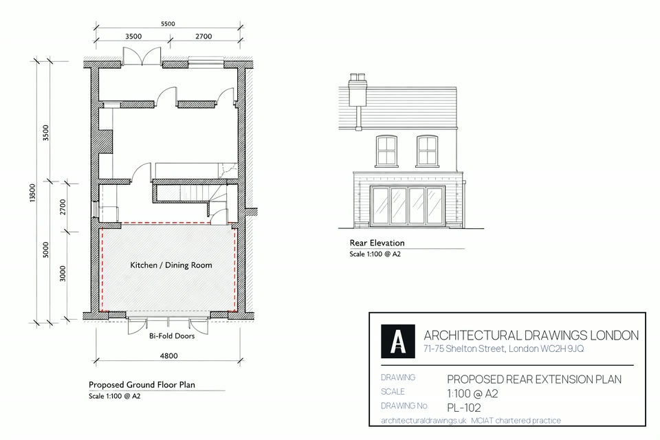
Proposed planExisting footprint in solid hatch, the new rear extension dimensioned against it.
A measured survey being recorded on site — conservation area planning in Havering.
Book a call
Speak to a chartered technologist — free 15 minutes
Pick a slot that suits you. No obligation and no sales pressure, just straight answers on your planning route.
Which Havering postcodes does this conservation area application service cover?
Which Havering districts we draw in, when their housing was built, and which council desk an application from each will land on. A note on the fee column: those are statutory England rates for 2026 and bear no relation to what the drawings themselves cost.
Postcode
Area
Dominant stock
What it means for a conservation area application
RM4
Havering-atte-Bower
Interwar semi-detached housing dominates Hornchurch and Upminster; Harold Hill and much of Romford are post-war; the older core of Romford keeps its Victorian streets.
RM4 is not Havering-only; it extends into Epping Forest and Brentwood. Conservation areas belong to the authority that designated them, so an area in the Epping Forest part of RM4 is Epping Forest’s designation and Epping Forest’s decision, not Havering’s.
RM5
Collier Row
1930s semi-detached
Collier Row occupies RM5 on its own, and Havering case officers apply the RM5 designation map to whatever is submitted from it.
RM1 is central Romford, all of it Havering's, and the Romford Market designation boundary runs through the district.
What changes about a conservation area application in each part of Havering?
Havering is 42.9% built-up land where London averages 66.0%, so plots here tend to run deeper and the roofs vary more. Both of those things change what a conservation-area scheme can reach at a given address.
Romford (RM1, RM2, RM7) — Victorian and post-war centre defines Romford, where victorian terraces, 1930s semi-detached, post-war flats set what a conservation area application can do. Most applications on these Victorian streets are householder applications validated on existing and proposed plans across RM1. Any Romford conservation area application is validated by Havering Council, with Romford Market the usual Romford reference point on the site plan.
Hornchurch (RM11, RM12) — a conservation area application in Hornchurch starts from 1930s semi-detached, and Hornchurch reads as 1930s semi-detached. On these 1930s semis the prior approval route often replaces a full application in RM11. Havering Council assesses Hornchurch conservation area applications against its own Hornchurch character guidance, and the location plan we draw for Hornchurch references Hornchurch Tube.
Upminster (RM14) — conservation area application work in Upminster means 1930s semi-detached, edwardian villas. Upminster is 1930s semi-detached, Edwardian villas. Edwardian houses here typically need the same householder set plus a roof plan where a dormer is proposed throughout RM14. Havering Council decides the Upminster application, and Upminster station anchors the Upminster location plan.
Rainham (RM13) — a conservation area application in Rainham starts from 1930s semi-detached, and Rainham reads as 1930s semi-detached, village fragments. On these 1930s semis the prior approval route often replaces a full application in RM13. Havering Council assesses Rainham conservation area applications against its own Rainham character guidance, and the location plan we draw for Rainham references Rainham Village.
Harold Hill (RM3) — a conservation area application in Harold Hill starts from post-war estate, and Harold Hill reads as post-war estate. Post-war stock here frequently sits inside an estate layout in RM3. Havering Council assesses Harold Hill conservation area applications against its own Harold Hill character guidance, and the location plan we draw for Harold Hill references Harold Hill.
Collier Row (RM5) — a conservation area application in Collier Row starts from 1930s semi-detached, and Collier Row reads as 1930s semi-detached, post-war. On these 1930s semis the prior approval route often replaces a full application in RM5. Havering Council assesses Collier Row conservation area applications against its own Collier Row character guidance, and the location plan we draw for Collier Row references Collier Row Road.
Elm Park (RM12) — conservation area application work in Elm Park means 1930s semi-detached. Elm Park is 1930s semi-detached. On these 1930s semis the prior approval route often replaces a full application throughout RM12. Havering Council decides the Elm Park application, and Elm Park Tube anchors the Elm Park location plan.
What local planning policy applies to a conservation area application in Havering?
Conservation areas in Havering: fifteen of them, and Rainham Village, Romford Market and Upminster are the ones owners here run into most. Designation takes away the permitted-development route, so what would have been a £249 prior approval settled in 6 weeks becomes a £548 householder application settled in 8. In Rainham Village the street elevation is the thing judged first, and the drawings ought to be prepared in the knowledge of that.
Havering permitted development status: there is no borough-wide direction from Havering Council, so a conservation area application at a RM1 address is normally still permitted development. We certify that with a £274 Lawful Development Certificate rather than leaving a Havering sale to argue it later.
What Havering is built from: 1930s semi-detached dominates Hornchurch and Upminster; post-war in Harold Hill and Romford; Victorian in older Romford centre. Outer east London; Metropolitan Green Belt covers north of the borough; permissive residential planning; strong PD use. That mix decides the conservation area application route in Havering more than the postcode does.
Who decides a conservation area application on the edge of Havering?
Barking and Dagenham — cross the Havering boundary and Barking and Dagenham Council takes the conservation area application instead, applying 9 conservation areas of its own around IG11. We re-price conservation area applications at the Havering edge because Barking and Dagenham policy and Havering policy rarely align on conservation area application depth.
Redbridge — the Redbridge boundary runs against Havering, so a conservation area application a street from Havering is decided by Redbridge Council instead. Redbridge runs 14 conservation areas across E11 and its neighbours, which is why conservation area applications priced for Havering are re-checked against Redbridge policy whenever the Havering address sits on that edge.
Sources for this Havering conservation area application page: borough policies maps and
conservation-area registers (2025–26), Royal Mail postcode district boundaries,
the Town and Country Planning (Fees for Applications) (England) Regulations, the Town
and Country Planning (General Permitted Development) (England) Order 2015 as amended,
and the Party Wall etc. Act 1996.
The planning set that goes to the council through the Planning Portal: proposed elevations, plans, and the OS location plan with your site outlined.