
Measured Building Surveys · N20 Whetstone
Barnet protects the Totteridge Village conservation area and extensive surrounding green belt; Totteridge is among the borough's most expensive areas, with very large plots and strong design control.

Trees as much as walls. N20 covers Whetstone and Totteridge in Barnet, a borough carrying 3,215 tree preservation zones in the national register — the second highest count in London — alongside 48 Article 4 areas and 16 conservation areas over 1,243 hectares.
| Measure | Barnet | London |
|---|---|---|
| Tree preservation zones in the register | 3,215 | second most of the 9 boroughs in the tree register |
| Article 4 areas in the register | 48 | — |
| Conservation areas | 16 covering 1,243 ha | 1,141 |
| Householder approval rate | 83.5% | 83.0% |
| Householder appeals allowed after refusal | 49.1% of 927 | 40.8% of 13,067 |
| Measured survey, floor plans from | £245 | our fixed fee |
Sources: registers from the MHCLG Planning Data Platform, retrieved 1 September 2026, excluding revoked and superseded entries; decision figures from MHCLG PS1 and PS2, twelve quarters to March 2026; appeals from Planning Inspectorate casework decided 2016–2026; the survey fee is our own published fixed fee. Totteridge in particular sits inside a large designated area, so the survey and the constraint check belong together.
Whetstone N20 — local contextThis page is about one district. Fees, timelines and the council's current position across the whole borough sit on measured building surveys in Barnet.
A measured building survey records the Whetstone house exactly as it stands — every wall, opening, level and boundary — and everything drawn afterwards is drawn from it. On the older stock around Whetstone and Totteridge, walls are rarely square and floors rarely level, and an error carried into a proposed plan resurfaces as an officer query at the worst possible moment. Of 4,584 householder applications Barnet determined across twelve quarters to March 2026, 756 were refused. Contradictory drawings account for a share of those, and they are the cheapest cause of refusal to remove.
Point-cloud scanning with a BLK360, laser measurement with a Leica Disto, deliverables in Revit and AutoCAD, technologists MCIAT chartered.
Across Whetstone, Totteridge, Totteridge Village, Oakleigh Park fringe in N20, the dominant property is inter-war semis and large detached houses around whetstone and totteridge, with the green-belt totteridge village and generous plots. That stock shapes what measured building survey looks like here: the right approach for a period terrace differs from a mansion-block flat or a new-build, and Barnet Council judges each on design quality and neighbour impact. We survey the specific Whetstone property, confirm the planning route — Permitted Development, a Lawful Development Certificate, or full planning — and draw a council-ready set tailored to the N20 streetscape.
Housing stock in N20: inter-war semis right through Whetstone, giving way to large detached houses on generous plots towards Totteridge village, with green belt beyond the Common.
Within the district: Whetstone, Totteridge, Totteridge Village, Oakleigh Park fringe.
Streets we know in N20: the Totteridge Lane and Totteridge Common roads, the Whetstone High Road streets and the large plots toward the village. Each road has its own building line, boundary treatment and precedent that Barnet Council weighs when assessing a measured building survey scheme.
Conservation areas: Totteridge Village, and the High Road frontage at Whetstone. Within either, external work generally means full planning and a Heritage Statement.
Getting around N20: Totteridge & Whetstone on the Northern line, plus Great Northern services from Oakleigh Park.
Property values: a median N20 sale price of £731,900 through 2025, from 242 recorded transactions (HM Land Registry Price Paid) — the soundest available gauge of what an extension or a loft is being added to.
The borough behind the district: volume rather than novelty is what Barnet’s planning service deals in — 8,047 applications of every type came to a decision across MHCLG’s three reported years to March 2026, 2,505 applications of them minor schemes. Whetstone contributes a steady run of inter-war semis to that total, consistent in plan and rarely consistent in rear elevation, which is where the scanning earns its keep. Contains public sector information licensed under the Open Government Licence v3.0
Borough character: outer-London suburbia at scale, 160,460 dwellings with 21.2% of them dating from the 1930s (VOA CTSOP4.1, 31 March 2025). Permitted development carries most householder work here. Elsewhere in Barnet, Hampstead Garden Suburb layers a residents' trust and its own design controls over the council's.
A chartered technologist arrives at the Whetstone address carrying a BLK360 scanner and a Leica Disto. Ninety minutes covers a three-bed semi off Totteridge Lane.
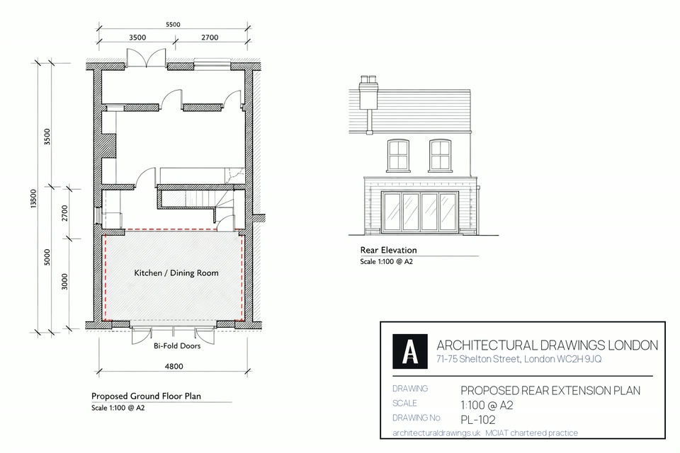
The set is drafted at 1:50 or 1:100 in Revit or AutoCAD, to a 3mm tolerance, with every room, opening, fitting and service annotated.
All four elevations, plus cross-sections. Barnet Council, the party wall award and the structural engineer each need them, and each needs them agreeing with one another.
The BLK360 returns a full 3D point cloud, which is the right tool for a Totteridge villa, for anything listed, and for any roof that has been altered more than once.
You receive DWG, RVT, PDF and IFC together. Whichever of the three your architect, engineer or builder works in, nothing needs converting.
An RICS-compliant accuracy report travels with the set: 3mm point-to-point, 5mm absolute. That is the sign-off Barnet Council, a party wall surveyor and an insurer will each accept.
Single planning or building-regs submission.
Planning + building regs + structural.
Listed, conservation or complex sites.

Yes. Most of Whetstone is inter-war semis. They take rear, side and loft extensions well, and a good share of that work runs under Permitted Development. The larger houses along Totteridge Lane and around the Common have the plot for something more ambitious, but most fall inside the Totteridge Village conservation area or the green belt and need a full application. We settle which of the two governs before any design starts.
Very. The Totteridge Village conservation area and the green belt wrapped around it exist to hold the low-density, semi-rural character of Totteridge Lane and the Common. Extensions there are judged on plot coverage, height, openness and impact on trees, not on floor area alone. We design inside those tests and run the Barnet application with heritage and arboricultural input alongside.
Usually yes, on the Whetstone semis lying outside the conservation areas and the green belt: a hip-to-gable and rear dormer kept within the volume allowance, then recorded through a Lawful Development Certificate. Over on the Totteridge estates and within the green belt, any change to the roof form needs full planning. We establish which one applies at the survey visit.
From the Whetstone semis to the large houses on Totteridge Lane, a consented extension or loft buys family space and sale value together; the district median stood at £731,900 in 2025 on 242 recorded sales. Green belt and conservation controls set a high bar over the Totteridge end, so the drawings have to answer the policy and not only the brief.
The drawing fee is small measured against the asset it alters. The median N20 sale in 2025 was £731,900, from 242 transactions in HM Land Registry Price Paid data pulled in September 2026, well clear of the £583,000 Barnet median across 3,567 sales in the same year. Barnet Council then adds its own statutory charge: a householder planning application is £548 and a full application £610. The drawings are quoted at one fixed price, and the site visit is free at any N20 address.
An N20 job reaches the council three or four weeks after you instruct us: week one is the survey, weeks two and three the drawings plus whatever you want changed, then validation and the eight statutory weeks Barnet Council has to determine a householder application. Every officer query that follows is answered by us, right through to the decision notice.
Whetstone and Totteridge sit wholly within Barnet, so Barnet Council decides every application from an N20 address. No borough-wide Article 4 Direction strips householder permitted development rights here. Two conservation areas reach into the district, Totteridge Village and the Whetstone High Road frontage, and inside those a full application and a Heritage Statement apply. Which of those governs your address is settled before we put a figure on the work.
Almost always. Structural work following a Whetstone survey — new openings, steel beams, a loft floor, underpinning — has to clear Building Regulations: Part A on structure, Part L on insulation, Part B on means of escape, which goes to Barnet Council Building Control, or alternatively to an approved inspector. On the semi-detached and terraced stock filling N20, a Party Wall notice to the adjoining owner comes first, ahead of any steel. Both sit inside the Complete package.
In value terms yes, provided the scheme gets through. With the N20 median at £731,900 in 2025 (HM Land Registry Price Paid, 242 sales), an extension or loft that adds genuine floor area usually returns more than it costs. The risk sits in the consent, not the build. Barnet's appeal record shows what a refusal actually buys you: 2,648 appeals reaching a decision, 1,022 allowed and 1,626 dismissed, an allowed share of 38.6%. Do not read that as an approval rate. The appellants are only those who were refused and elected to fight, and even inside that self-selected group three in five still lose, after months of waiting. Correct drawings first time cost far less than being proved right on appeal.
Local policy varies more between adjoining boroughs than most owners expect. Full service detail for N2, N3, N10, N12, NW2, NW4, NW7 and NW11.
Pick a slot that suits you. No obligation and no sales pressure, just straight answers on your planning route.
The N20 streets we draw in, what was built along them, and who validates a measured building survey there. Fees listed below are England statutory rates for 2026, not our survey fees.
| Postcode | Area | Dominant stock | What it means for a measured building survey |
|---|---|---|---|
| N20 | Whetstone / Totteridge | 1930s semi-detached, Edwardian villas | Whetstone and Totteridge both fall entirely within N20, so every measured building survey submitted from an N20 address is validated by Barnet Council. |
| N20 | Whetstone | 1930s semi-detached, Edwardian villas | Whetstone lies inside N20, and Barnet Council determines the measured building survey proposals that come from those addresses. |
| N2 | East Finchley | Edwardian terraces, 1930s semi-detached | Adjoining district to N20. A survey is a record rather than an application, so nothing about it changes at the Barnet boundary. |
| N3 | Finchley Central | 1930s semi-detached, Edwardian villas | Adjoining district to N20. A survey is a record rather than an application, so nothing about it changes at the Barnet boundary. |
| N11 | New Southgate / Bounds Green | mixed stock | Adjoining district to N20. A survey is a record rather than an application, so nothing about it changes at the Barnet boundary. |
| N12 | North Finchley / Woodside Park | 1930s semi-detached, Edwardian villas | Adjoining district to N20. A survey is a record rather than an application, so nothing about it changes at the Barnet boundary. |
Ridge height, wall build-up and plot depth shift inside a few hundred metres in N20, and all three govern what a survey at that address is able to support.
How designation changes an N20 (Whetstone / Totteridge) measured building survey: two conservation areas touch this district, Totteridge Village and the Whetstone High Road frontage. Inside either, a survey here cannot lean on permitted development: the route turns into a householder application at £548, decided over 8 weeks, when the prior approval alternative is £249 over 6 weeks. Totteridge Village shapes more N20 casework than the other, because its controls extend to plot coverage and tree cover as well as elevations.
Article 4 and your N20 (Whetstone / Totteridge) measured building survey: no direction covering the whole borough has been made, which leaves permitted development intact at N20 addresses outside the two conservation areas and away from listed curtilages. At £274, a Lawful Development Certificate is the instrument that puts the lawfulness of the work on the public record. Barnet recorded 2,585 of them over the three years to March 2026 — recorded, note, not granted: the national return carries no approval rate for certificates, in Barnet or in any other English authority.
N20 (Whetstone / Totteridge) housing stock: 1930s semi-detached dominates the Whetstone streets, giving way to larger detached houses and a scatter of older cottages towards Totteridge village, with green belt past the Common. Across the borough, 21.2% of Barnet's 160,460 dwellings date from 1930-39 and 13.5% from 1900-18 (VOA CTSOP4.1, 31 March 2025). Construction rather than postcode sets what is achievable, so read the building before choosing a survey route. The statutory charge from Barnet Council is £548 on a householder application, with 8 weeks to decide it.
Sources for this N20 measured building survey page: borough policies maps and conservation-area registers (2025–26), Royal Mail postcode district boundaries, the Town and Country Planning (Fees for Applications) (England) Regulations, the Town and Country Planning (General Permitted Development) (England) Order 2015 as amended, and the Party Wall etc. Act 1996.
Free fixed quote in 60 seconds. MCIAT chartered.
Get my free quote →Or contact us about your project firstYou can browse every service and area to find the right fit, or open a client account to track your project. When you are ready, get a quote today — most homeowners have a fee in minutes — or contact us about your project and a chartered technologist will be in touch.

